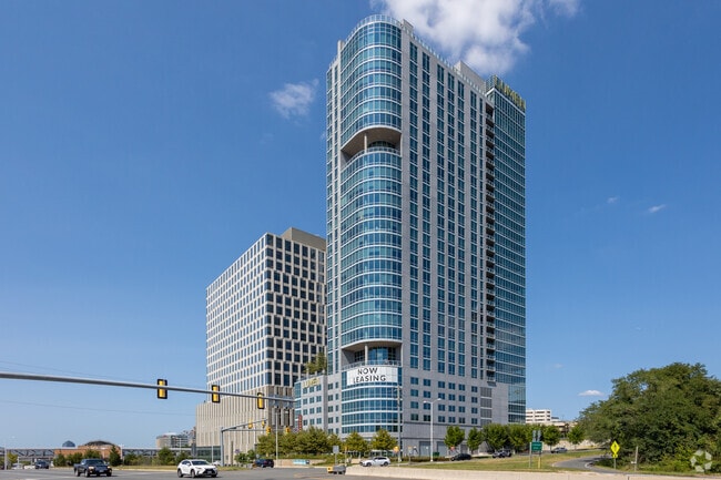
Property Record
8334 Leesburg Pike, Vienna, VA 22182
Current Lease Availabilities
NEARBY LISTINGS FOR SALE OR LEASE
Property Detail
8334 Leesburg Pike
0293T01-0076B
Tysons Corner
Regionalshoppingcenterormallwithanchorstore
TYSONS CORNER COMMERCIAL COMPONENT OF 0293 01 0076B
X
Fairfax
5100540015D
Virginia
2024
76b
2025
Tysons Central
480205
Washington, DC
12,259 SF
Washington-Arlington-Alexandria, DC-VA-MD-WV
DEMOGRAPHICS near 8334 Leesburg Pike
1 Mile
3 Mile
5 Mile
2024 Total Population
20,260
110,260
259,513
2029 Population
20,482
109,514
256,521
Pop Growth 2024-2029
+ 1.10%
(0.68%)
(1.15%)
Average Age
40
40
40
2024 Total Households
10,050
43,250
96,043
HH Growth 2024-2029
+ 1.43%
(0.62%)
(1.21%)
Median Household Inc
$131,183
$159,178
$162,286
Avg Household Size
2.00
2.50
2.60
2024 Avg HH Vehicles
1.00
2.00
2.00
Median Home Value
$732,752
$886,691
$851,207
Median Year Built
1996
1984
1978
Nearby Places
- Restaurants
- Banks
- Shops
- Fitness
- Groceries
PUBLIC TRANSPORTATION
TRANSIT/SUBWAY
Greensboro (Silver Line - Washington Metropolitan Area Transit Authority Metrorail (Metrorail))
DRIVE
WALK
Distance
Greensboro (Silver Line - Washington Metropolitan Area Transit Authority Metrorail (Metrorail))
6 min
0.3 mi
Tysons Corner (Silver Line - Washington Metropolitan Area Transit Authority Metrorail (Metrorail))
DRIVE
WALK
Distance
Tysons Corner (Silver Line - Washington Metropolitan Area Transit Authority Metrorail (Metrorail))
4 min
10 min
0.6 mi
Spring Hill (Silver Line - Washington Metropolitan Area Transit Authority Metrorail (Metrorail))
DRIVE
WALK
Distance
Spring Hill (Silver Line - Washington Metropolitan Area Transit Authority Metrorail (Metrorail))
16 min
0.8 mi
COMMUTER RAIL
Backlick Road (Manassas Line - Virginia Railway Express)
DRIVE
WALK
Distance
Backlick Road (Manassas Line - Virginia Railway Express)
15 min
9.2 mi
AIRPORT
Washington Dulles International
DRIVE
WALK
Distance
Washington Dulles International
16 min
13.6 mi
Ronald Reagan Washington Ntl
DRIVE
WALK
Distance
Ronald Reagan Washington Ntl
21 min
16.7 mi
Freight Ports
Port of Baltimore
DRIVE
WALK
Distance
Port of Baltimore
1 min
41.5 mi
Nearby Properties
Address
Land Use
TOTAL SIZE
Lot Size
Zoning
Address
Land Use
TOTAL SIZE
Lot Size
Zoning
2,385,458 SF
62.90 AC
403
Address
Land Use
TOTAL SIZE
Lot Size
Zoning
562,860 SF
23.56 AC
400
Address
Land Use
TOTAL SIZE
Lot Size
Zoning
964,537 SF
5.06 AC
360
Address
Land Use
TOTAL SIZE
Lot Size
Zoning
915,666 SF
2.77 AC
360
Address
Land Use
TOTAL SIZE
Lot Size
Zoning
729,473 SF
3.89 AC
360
Address
Land Use
TOTAL SIZE
Lot Size
Zoning
553,360 SF
1.99 AC
403
Address
Land Use
TOTAL SIZE
Lot Size
Zoning
842,366 SF
16.74 AC
400
Address
Land Use
TOTAL SIZE
Lot Size
Zoning
613,642 SF
19.08 AC
330
Address
Land Use
TOTAL SIZE
Lot Size
Zoning
929,735 SF
21.95 AC
430
Address
Land Use
TOTAL SIZE
Lot Size
Zoning
431,636 SF
3.25 AC
360
Address
Land Use
TOTAL SIZE
Lot Size
Zoning
510,357 SF
3.03 AC
360
Address
Land Use
TOTAL SIZE
Lot Size
Zoning
567,363 SF
2.39 AC
360
Address
Land Use
TOTAL SIZE
Lot Size
Zoning
475,471 SF
2.51 AC
360
Address
Land Use
TOTAL SIZE
Lot Size
Zoning
402,531 SF
0.97 AC
360
Address
Land Use
TOTAL SIZE
Lot Size
Zoning
455,583 SF
3.51 AC
400
Address
Land Use
TOTAL SIZE
Lot Size
Zoning
601,758 SF
3.70 AC
360
Address
Land Use
TOTAL SIZE
Lot Size
Zoning
601,409 SF
3.89 AC
360
Address
Land Use
TOTAL SIZE
Lot Size
Zoning
505,415 SF
1.95 AC
403
Address
Land Use
TOTAL SIZE
Lot Size
Zoning
363,805 SF
2.64 AC
350
Address
Land Use
TOTAL SIZE
Lot Size
Zoning
483,000 SF
1.98 AC
360
Address
Land Use
TOTAL SIZE
Lot Size
Zoning
584,872 SF
10.58 AC
470
Address
Land Use
TOTAL SIZE
Lot Size
Zoning
290,749 SF
1.49 AC
403
Address
Land Use
TOTAL SIZE
Lot Size
Zoning
425,118 SF
16.99 AC
320
Address
Land Use
TOTAL SIZE
Lot Size
Zoning
440,641 SF
3.11 AC
360
Address
Land Use
TOTAL SIZE
Lot Size
Zoning
346,335 SF
1.42 AC
350
Address
Land Use
TOTAL SIZE
Lot Size
Zoning
356,812 SF
0.92 AC
400
Address
Land Use
TOTAL SIZE
Lot Size
Zoning
520,200 SF
4.53 AC
360
Address
Land Use
TOTAL SIZE
Lot Size
Zoning
394,539 SF
15.87 AC
230
Address
Land Use
TOTAL SIZE
Lot Size
Zoning
B-2 CENTRA
Address
Land Use
TOTAL SIZE
Lot Size
Zoning
338,000 SF
1.23 AC
360
The World's #1 Commercial Real Estate Marketplace
Connect with us
© 2025 CoStar Group
The information above has been obtained from sources believed reliable. While we do not doubt its accuracy we have not verified it and make no guarantee, warranty or representation about it. It is your responsibility to independently confirm its accuracy and completeness. Any projections, opinions, assumptions, or estimates used are for example only and do not represent the current or future performance of the property. The value of this transaction to you depends on tax and other factors which should be evaluated by your tax, financial, and legal advisors. You and your advisors should conduct a careful, independent investigation of the property to determine to your satisfaction the suitability of the property for your needs.